
El Niño Could Ignite Eastern Pacific Hurricane Season in 2026, Raising Risks for Southern California
El Niño conditions developing in 2026 are expected to boost Eastern Pacific hurricane activity by warming ocean temperatures and reducing wind shear, increasing the chance of rapid intensification and greater impacts for coastal Mexico and the U.S. West Coast.
- El Niño favors a more active Eastern Pacific: warmer seas and often lower local shear can feed stronger storms (Fox Weather, YouTube).
- NOAA-model outlook: roughly a 61% chance El Niño forms in May–July 2026 and ~25% chance of a Super El Niño by fall, increasing storm-intensity risk (Time).
- Atlantic suppression: El Niño typically raises Atlantic upper-level winds and shear, reducing hurricane odds there (AccuWeather).
- Local preparedness matters: inland communities such as Hesperia should review flood plans, infrastructure readiness, and public-alert systems ahead of a potentially active Eastern Pacific season.
Mechanism in the Eastern Pacific
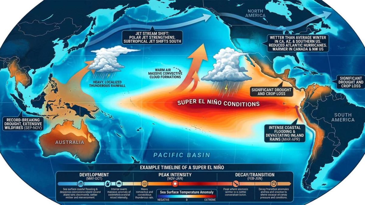
El Niño is a natural climate cycle that warms the central and eastern tropical Pacific. That additional heat alters the atmosphere: warmer air holds more moisture, feeding stronger convection and thunderstorms. In the Eastern Pacific this extra moisture and warmth often coincides with reduced vertical wind shear, allowing storms to stay upright and organize into tropical cyclones more easily (YouTube, Fox Weather).
“Lower shear lets storms stay upright and organize into tropical cyclones more easily,” a pattern repeatedly observed in past El Niño years.
Why the Atlantic is Different
By contrast, El Niño tends to strengthen upper-level winds across the tropical Atlantic and the Gulf of Mexico. That increased wind shear disrupts developing storms, which is why El Niño years often see suppressed Atlantic hurricane activity (AccuWeather).
Why it’s Igniting the 2026 Season
Three main factors are raising concern for the Eastern Pacific in 2026:
- Warm ocean heat content: Many parts of the Pacific are already 1–3°C above average, providing abundant fuel for storms; deep warm subsurface layers increase the potential for strengthening (Fox Weather, YouTube).
- Reduced local shear in the Eastern Pacific: El Niño often lowers shear locally, enabling storms to organize and persist, increasing the frequency of hurricanes and major hurricanes (YouTube).
- Potential for rapid intensification: Warm, deep waters can allow storms to strengthen quickly — Hurricane Otis (2023) is a stark example of how fast conditions can change near warm coastal waters (Fox Weather).
Historical context: El Niño years historically produce more named storms and a higher count of major hurricanes in the Eastern Pacific; some analyses suggest up to an 85% likelihood of above-average activity during moderate-to-strong El Niño events (YouTube).
Timing and Forecast Outlook
Timing is critical. If El Niño establishes before mid-summer, the Eastern Pacific may be primed early — producing a busier season starting with the official May 15 opening. Current analyses estimate ~61% odds of El Niño forming in May–July 2026, with about a 25% chance it evolves into a Super El Niño by fall, which could push sea surface anomalies to 2–3°C above normal in some areas and increase both the number and intensity of storms (Time, Fox Weather).
If El Niño strengthens late, the Atlantic may briefly experience a window for hurricane production earlier in summer; however, a strong, early El Niño will likely shift the balance toward a significantly active Eastern Pacific season.
Impacts for Coastal Communities and the U.S. West
An active Eastern Pacific season raises the likelihood of storms forming closer to Mexico and off the Pacific coast, increasing risks of heavy rainfall, coastal flooding, and dangerous surf for parts of California and the Southwest if storm tracks shift northward. Preparedness and early coordination are essential.
Risk Lessons from Hurricane Otis Rapid Intensification
Hurricane Otis (2023) highlighted how a storm can go from tropical to catastrophic in hours. Rapid intensification compresses warning time for communities and emergency managers, making pre-planning, staged resources, and rapid-alert systems vital for saving lives and property (Fox Weather).
Implications for Hesperia, California
Although Hesperia lies inland in Victor Valley, the city can still face secondary impacts from an active Eastern Pacific season: flooding from intense rainfall, overwhelmed drainage, and regional transport disruptions. Below are targeted considerations across economic, political, social, and cultural dimensions.
Economic impact
– Flooding and infrastructure strain: Intense Pacific storms can funnel deep moisture into Southern California, causing flash flooding and damage to roads, bridges, and supply chains.
– Insurance and rebuilding costs: Increased claims can pressure homeowners and small businesses; reviewing flood and wind coverage is recommended.
Political and emergency-management effects
– Local government readiness: City and county services should update evacuation routes, flood maps, and communication plans; transparency and clear planning are key.
– Intergovernmental coordination: A strong season could require coordination with San Bernardino County, state agencies, and FEMA for response and recovery.
Social effects and public safety
– Short-warning hazards: Rapid intensification risks mean residents need go-bags, evacuation plans, and reliable alert methods.
– Public health concerns: Flooding can cause water contamination, outages, and medical service interruptions — clinics and hospitals should plan surge capacity.
Cultural and practical relevance
Hesperia’s culture of neighbor-to-neighbor support is an asset: faith groups, service clubs, and volunteers often act as first responders. Strengthening these networks and coordinating with emergency services improves community resilience. Practical household steps — clearing gutters, securing outdoor items, and stocking supplies — matter.
What Local Leaders and Residents Should Do Now
- Review emergency plans: Reassess flood and evacuation plans with updated storm scenarios.
- Inspect and reinforce infrastructure: Prioritize clearing storm drains and reinforcing critical roadways.
- Communicate early and often: Use multiple channels — sirens, radio, text alerts, and local news — to reach residents quickly.
- Update insurance and supplies: Check flood/wind coverage and assemble emergency kits with water, food, medications, and fuel where appropriate.
Sources and further reading
- Fox Weather: El Niño could boost Eastern Pacific hurricane activity in 2026 — https://www.foxweather.com/weather-news/el-nino-boost-hurricane-activity-eastern-pacific-2026
- YouTube (briefing) — https://www.youtube.com/watch?v=JlHLQ_4U3t8
- YouTube (explainer) — https://www.youtube.com/watch?v=0PB-8tmAtrg
- Time: Super El Niño 2026 outlook — https://time.com/article/2026/04/10/super-el-nino-2026-what-to-know/
- AccuWeather: What El Niño means for U.S. weather in 2026 — https://www.accuweather.com/en/weather-forecasts/el-nino-is-brewing-heres-what-it-means-for-us-weather-in-2026/1865308
- Pacific hurricane season context — https://en.wikipedia.org/wiki/2026_Pacific_hurricane_season
Reporting by Times Media Service
